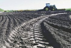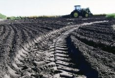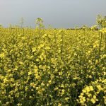

A new program involving Ontario’s Agricultural Information Atlas, commonly known as AgMaps, helps farmers determine the soil erosion potential of their fields.
The water erosion potential map has been in the making for years.
It takes advantage of information previously within the AgMaps portal and recently collected LiDAR (Light Detection and Ranging) remote survey data to help define the topography of landscapes and determine the soil site’s potential erosion.
Why it matters: Understanding water erosion potential can help to maintain topsoil.
Read Also
Ontario’s agri-food sector sets sights on future with Agri-Food 2050 initiative
The first-ever Agri Food 2050, a one-day industry event dedicated to envisioning the future of food and farming in Ontario,…
Kevin McKague, rural water quality engineer with the Ontario Ministry of Agriculture, Food and Rural Affairs (OMAFRA), says farmers experience a rainfall with high erosion every year.
AgMaps measures the amount of soil farmers potentially have to lose in terms of tonnes per acre per year.
“It gives you an appreciation of what soil loss you could expect and then you can say ‘OK, this (soil loss) is from doing one certain cropping or management practice, or tillage practice. Is that improving or making this worse?’”
As well, when farmers know they have an erosion issue, they can use AgMaps to see how other agronomy or tillage practices can help improve the situation.
“They can enter those options in, and see how much better it might make it.”
The water erosion potential map was added to OMAFRA’s AgMaps in early March.
McKague hopes the program will help farmers with their management of nutrients and other programs that OMAFRA plans to launch.
“The phosphorus loss assessment tool needs erosion rate. (Farmers) might not know what that number is. This is a tool that could help them estimate that to be used as input.”
The program is still in the early stages. McKague has noticed some glitches with the program and hopes to continue to improve them.
“In the next few months, I want to be able to upgrade it and improve some things. Make the program more readable for a user.”
The program is in the first of four stages.
Phase one, which was launched, is the sheet roller erosion. Phase two will help to map gully erosion and determine if there is a risk for producers. Phase three looks at tillage erosion, mapping the risk of it given the inherent field conditions. Phase four will identify places where grass waterway and buffers would be most effective given the topography and water movement.
“It’s a work in progress, gradually plugging away at it. From an OMAFRA standpoint, it was one of the things we identified in the provincial strategy — to improve our ability to map erosion potential.”
McKague hopes to have the program completed within the next two to three years but understands COVID-19 may change this timeline.
To try it out, search Google for AgMaps and Ontario.
As well, McKague posted a video on YouTube (search for Erosion Mapping Tool Demo) to guide producers on how to use the program to create a water erosion potential map.