

Polar vortex, snowmageddon, thunder snow. Such terms likely conjure scenes of wild and chilly weather but what do they actually mean?
Knowing the parameters used to determine the names of these and other systems might, quite literally, help farm businesses weather storms with fewer hardships.
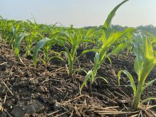
Why it matters: Understanding weather system terms can allow for better planning on and off the farm.
Read Also
Farm policy organizations worldwide consider their shared issues
Farmer organizations from several countries, Canada included, agree there is common ground among them, even as geopolitical tensions and economic uncertainties swirl.
As part of the 2022 Ontario Agricultural Conference, Jerry Shields, meteorologist and weather systems coordinator with the Ministry of Northern Development, Mines, Natural Resources and Forestry, provided definitions for a range of weather events.
Polar vortex has become a common term for extended periods of below-normal cold and were previously known as cold outbreaks. Shields says records of the phenomena reach back to the mid 19th century. Polar vortex is one of many clickbait terms used to refer to particularly nasty winter conditions.
Whatever its name, the phenomenon occurs when the jet stream surrounding the stable cold arctic air mass dips into more southerly locales. Lasting for days or even weeks, a polar vortex usually follows warm periods, which are also caused by a fluctuating jet stream, and increase the risk for flash freezing and damage to crops and farm infrastructure.
When it comes to snow, Shields says it’s helpful to know the differences between a snowfall warning, snow squall and blizzard.
Snowfall warnings are issued when accumulation potential reaches 15 centimetres or more within a 24-hour period. Snow squalls refer to significant snowfall within 12 hours, along with visibility reduced to half a kilometre. Blizzards are defined as snow with winds of at least 40 km per hour, as well as reduced visibility, for at least four hours.
Alberta clippers and Colorado lows are both strong, fast-moving systems originating near each namesake area. They can bring sudden moisture to Ontario. The low pressure of an Alberta clipper often brings four to six inches of snow within 12 to 18 hours but moves out quickly. Colorado lows, conversely, frequently bring rain (freezing or otherwise) followed by snow. Warm conditions generally precede Colorado lows.
“They are often a more severe event because it has more connection to moisture,” Shields says.
Thunder snow is another term sometimes heard in winter. Somewhat unique to Ontario, it refers to thunder and lightning during a snow event. Though not particularly dangerous, Shields says thunder snow is indicative of severe weather generally.
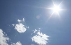
Extreme heat warnings are one thing but being under a heat dome is another.
Shields says the term is relatively new, referring to high pressure systems parked over central North America. Acting like an atmospheric convection oven, heat domes build on themselves to generate hot and dry conditions that can last for weeks. Impacts for agriculture include drought and extreme heat stress for plants, people and livestock.
“When you hear heat dome, think we’re going to have to irrigate or prepare for hardiness for plants to survive drought,” says Shields.
“You can pretty well guarantee temperatures are going to be outside normal climatic zones. So, if you have temperatures in the mid-20s cooling off into the low teens, well, you’re going to see temperatures of 30 to 40 degrees C, and overnight lows might even hang around in the 20 degree C mark.”
Tornadoes, waterspouts and funnel clouds are all related, but only tornadoes touch the ground. The others occur over open water or spiral in the sky. All are common in Ontario, though tornadoes often go unnoticed because they leave a narrow path of destruction and frequently occur in less populated regions.
“You get very little warning. Often you may get a warning and see a tornado all around the same time and need to take cover… You have to be on guard and that takes away from your ability to do other things,” says Shields, adding there are constant efforts to refine early warning and communications systems.
Wind patterns also have different definitions. Linear winds comprise most strong winds. Tornadoes are the most powerful. A downburst, however, can be confused for both. These come from thunderstorm activity and are characterized by strong air currents descending and spreading over a wide area. Downbursts often reach speeds of 100 to 120 km per hour, causing random damage. Like tornadoes, they can uproot trees, flatten crops and damage buildings.
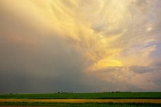
Atmospheric rivers, or areas of high moisture traveling along a narrow path, can cause significant and disruptive weather events such as the flood-level rainfall experienced in British Columbia last year. They can take a long time to dissipate.
Historically, atmospheric rivers are seen south of the border, but Shields says the trend has loosened in recent years, potentially a result of climate change.
The atmospheric river that battered British Columbia is colloquially known as “the pineapple express,” given its origins near Hawaii. Ontario has its own version, with substantial moisture, heat and humidity hurled north from the Gulf of Mexico. Hurricane activity can enhance the impact, making it difficult to predict moisture.
“It doesn’t require the hurricane move into Ontario. It just brings the moisture. We may end up with amounts that are drastically higher than what’s predicted,” Shields says.
“If you’re in that situation where you see a hurricane in the Gulf in the fall, late summer, you have some hot humid weather with the southerly flow winds, then you should pay attention.
“There is a chance for a very extreme precipitation event, especially when you’re in the transition when that weather is just about to move out.”
Weather bombs are another concern, particularly in fall and spring or when hurricanes and other large storm systems are in play.
“A weather bomb means get ready, we’re going to get some sort of precipitation,” Shields says. Routine storms can become intense under such conditions. People should expect much more than what’s initially anticipated if a weather bomb is possible.
The two Pacific Ocean cycles, El Nino and La Nina, have impacts spanning multiple continents. El Nino refers to periods where a large band of water in the eastern equatorial region of the Pacific is warmer than usual. In Canada this tends to generate warmer and dryer conditions, and for Ontario, milder winters. Under La Nina, those same Pacific waters are cooler than average, bringing wetter weather and potential for more storm activity.
The transition periods between them bring what is generally more stable weather. Shields says Ontario is experiencing a La Nina year, though it should weaken as spring approaches. However, the length and consistency of transition has been more random in recent years.
“Winter is where we really see this makes a difference in Ontario. It could mean more snow, better protection for crops on the ground overwintering. It could also mean more of a moisture reserve,” says Shields.
“There’s also ice storm potential in the back and forth with La Nina. More ice storms and freezing rain events can be a hindrance to infrastructure, damaging to some crops, especially treed areas.”
While little can be done about weather, Shields believes understanding the potential risks associated with them allows people to prepare and respond better.
As climatic changes manifest themselves, particularly regarding the jet stream, the necessity of knowledge grows.
“That jet stream isn’t consistently running west to east,” he says, referring to increasing instability in the all-important air current.
“Often the jet stream divides the cold air… As it moves north and south, it will impact Ontario and determine what kind of weather we’re going to get.”