Glacier FarmMedia | MarketsFarm – Be it the Canadian Prairies or the United States Midwest, spring-like weather is on its way for the first couple of weeks of March, said Drew Lerner, president and chief agricultural meteorologist for World Weather Inc. in Overland, Kan. Meanwhile, the dryness that has dominated parts of Argentina and Brazil is likely to continue for the next several weeks.
“The heart of the Prairies, from central and eastern portions of Alberta, to western and southeastern parts of Saskatchewan will probably not see a lot of moisture during the next two weeks,” stated Lerner.
Read Also

China lifts Brazilian poultry imports ban over bird flu
China lifted a ban linked to Brazil’s avian influenza outbreak, the country’s General Administration of Customs said in a notice released on Friday.
However, northeastern Saskatchewan and parts of Manitoba are to see rain, as should “the front range of Alberta” and southwestern Saskatchewan near the U.S. border. However, amounts might not be that great depending on the area with maybe up to five millimeters of rain and a few inches of snow.
“A very similar pattern as we had in February. The only difference is it won’t be as cold,” said Lerner, adding the first week of March should see above-normal temperatures and then cooler for the second week.
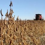
Rain for Midwest
As for the U.S. Midwest, Lerner said he expects an “active weather pattern” that’s likely produce to waves of precipitation.
Specifically, he forecast a good amount of moisture for Iowa, which has been rather dry over winter. That state is to get towards two inches of rain, while to the east, the rest of the Midwest is to get more precipitation. Lerner suggested that might delay spring planting in the already moist region.
Minnesota, North and South Dakota, as well as parts of the neighbouring states “are to keep a bit of a dry bias for a few weeks,” he said.
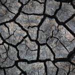
Drier in much of Argentina, Brazil
On the other side of globe, Lerner said the southern and western parts of Argentina are forecast to get a good amount of rain, likely two to six inches during the first half of March. Then northeastern Argentina is to remain dry with any rainfall unlikely to help its situation. He added that southern Brazil will have much the same pattern, but with a bit more rain.
Going into the central parts of Brazil, he said the dryness is likely continue, adding stress on the region’s crops.
For Mato Grosso, Lerner said the Brazilian state already has a fair bit of soil moisture, with more rain to come. However, he said it’s unclear if there will be enough in the ground to carry the region through the reproductive stage when conditions turn drier in April.
No official La Nina
Lastly, Lerner said there wasn’t a La Nina event this winter officially. However, the U.S. Climate Prediction Centre “kind of stretched the rule a little bit.” He said the cooler conditions needed for a La Nina usually for three months, but they lasted for about half that.