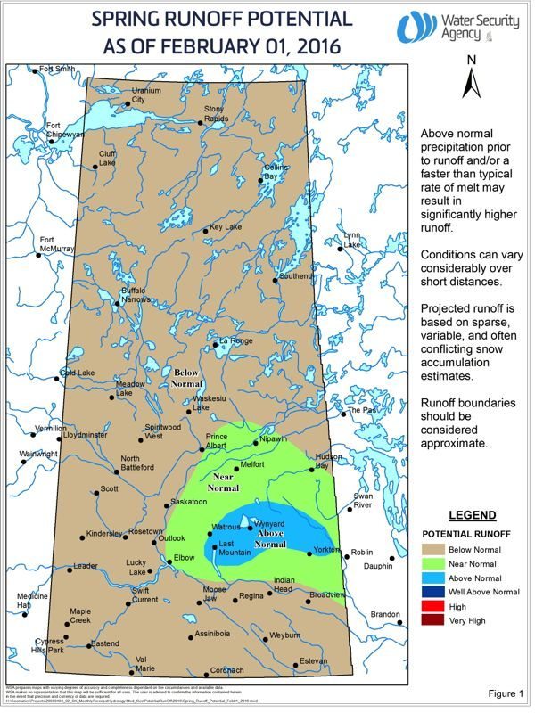

Barring any weather surprises, most of Saskatchewan outside of east-central regions can expect below-normal runoff this spring.
The province’s Water Security Agency on Tuesday released a preliminary outlook which, based on a “warmer- and drier-than-normal winter” and a resulting snowpack below normal levels, points to below-normal spring runoff.
Exceptions include parts of the east-central region, running from north of Yorkton up to Hudson Bay and west over to Nipawin, where the snowpack is “near normal.”
An area running from Yorkton west toward the north end of Last Mountain Lake, northwest of Regina, may see above-normal runoff based on current conditions, the agency added.
Read Also

Pulse Weekly: SaskPulse optimistic despite input, crop price concerns
SaskPulse executive director Carl Potts is optimistic ahead of the planting season despite lower crop prices and the war in Iran.
Most long-range precipitation forecasts call for near-normal precipitation across Saskatchewan for February, March and April, the agency said, but noted such long-range forecasts “are difficult to rely on.”
All those forecasts also point to above-normal temperatures for the three-month period, which suggests runoff could come earlier than usual.
Most reservoirs and dugouts went into winter at near-normal levels, the agency said, so even with below-normal runoff, surface water supplies are expected to be “adequate” this year. — AGCanada.com Network