

The forecasted storm system impacted the prairies pretty much as predicted with the main belt of snow falling in an arch from southern Manitoba and southeastern Saskatchewan northwest towards Edmonton.
Behind this low, cold Arctic air has invaded the Prairies much to many people’s surprise. We have gotten so used to mild spring-like weather that some people may be put off that winter has returned. For those who read my last column, this type of weather shouldn’t be surprising since we are now moving into what can be the snowiest time of the year.
Read Also

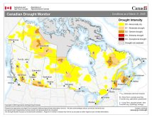
Canadian drought conditions improve in March
Normal to above normal precipitation in March helped moisture conditions improve across much of Canada, according to the latest Canadian Drought Monitor data from Agriculture and Agri-Food Canada
There are two questions going into this forecast period. The first is if the cold weather will stick around. The second question is–are we going to see more stormy weather? It looks like we’ve undergone a pattern shift. That shift is looking more cold and stormy than we have seen for most of this winter.
We start this forecast period with an area of Arctic high pressure sitting over Saskatchewan. It’s bringing some of the coldest weather so far this year. At the same time, an area of low pressure is moving inland off the coast of B.C. This low will quickly push the Arctic air northwards as it tracks across the central prairies on Thursday and Friday.
Arctic air will once again try to push southwards behind this low over the weekend, but it will have a hard time making inroads as a second area of low pressure crashes ashore in southern B.C. early in the weekend. This low looks like it could bring another round of measurable snow to the southern prairies late in the weekend, with the potential for a fairly major storms to evolve over parts of Saskatchewan and much of southern and central Manitoba.
Alberta
A sunny, cold start to this forecast period. The cold air will be quickly pushed out on Wednesday as an area of low pressure moves into southern B.C. The southerly flow ahead of this low will push daytime highs above freezing over southern regions on Wednesday and Thursday. Central and northern regions seeing highs in the -5 to -10 C range.
Clouds will increase on Thursday as the low lifts toward the northeast, bringing a good chance of snow to areas north of Edmonton. Skies will try to clear out behind the low, but a second low moving into B.C. on Saturday will begin to spread clouds back across the region.
As a deep trough develops along the west coast, it will force this second low to drop south as it begins it track to the east. Southern regions could see some measurable snow as the low tracks by to the south. Current indications around 5 cm is possible. Skies look to clear by Monday as weak Arctic high pressure builds in bringing a return to slightly below average temperatures for early March.
Saskatchewan
It will be a cold start on Wednesday across Saskatchewan as Arctic high pressure sits over the region. Luckily, it looks like the cold temperatures will only stick around for the day as the western low quickly tracks from southern B.C. northeast into the northern half of the province by Thursday.
Expect daytime highs to start moderating overnight Wednesday and to keep warming into Thursday night and Friday. By Friday, daytime highs will likely be in the +5 C range across most regions. Any snow from this low should remain over the northern half of the province. Colder temperatures will work back southwards on Saturday as cold air pushes in behind the departing low. Expect daytime highs to drop back down into the -8 to -11 C range with overnight lows falling to around -17 C.
Over the weekend, a second area of low pressure will be winding up over the northwestern U.S. While confidence is low in the exact track of this low, the models have been persistent in its development. Currently it looks like the low will track from the Colorado/Wyoming area, northeast toward southeastern Manitoba.
An inverted trough is forecasted to develop to the northwest of the low, which would bring a band of measurable snow to part of south-central and southeastern Saskatchewan on Sunday. The low is forecasted to pull toward the east by Monday and bring a return of sunny-to-partly-cloudy skies and continued below-average temperatures to begin the first full week of March.
Manitoba
After a stormy start to the week, Wednesday will see sunny skies and cold temperatures as Arctic high pressure dominates. Expect daytime highs be in the -15 to -18 C range with overnight lows Wednesday night again dropping into the mid -20’s.
As the western low tracks towards northern Manitoba on Thursday and Friday, southern and central regions will see a quick jump in temperatures with daytime highs by Friday forecasted to be around +3 C. As the northern low tracks by, colder air will work southwards behind the low with daytime highs expected to drop back down to around -10 C over the weekend.
Along with the colder temperatures over the weekend, all eyes will be turning towards a possible Colorado low. I will provide an update on Saturday as the picture becomes clearer. Current indications are that the low will track towards southeastern Manitoba on Sunday. It should bring significant snowfall to the areas west of the low’s track and a mixed bag of precipitation to the east of the track. Snowfall amounts are currently forecasted to be in the 10 to 20 cm range with the highest amounts expected to fall from southwestern Manitoba northeast toward Lake Winnipeg.
The snow will come to an end on Monday and skies will clear as cold arctic air pushes south behind the departing low. These cold temperatures look to stick around until at least Wednesday before more seasonable temperatures are expected to move back in.